Blog Archive

Sunday, May 21, 2023

05-20-2023-2259 - North Woolwich

From Wikipedia, the free encyclopedia
North Woolwich
North Woolwich ferry terminal, side view - geograph.org.uk - 1736806.jpg
North Woolwich ferry terminal
North Woolwich is located in Greater London
North Woolwich
North Woolwich
Location within Greater London
Population4,752 [citation needed]
OS grid referenceTQ435795
• Charing Cross8 mi (12.9 km) WNW
London borough
Ceremonial countyGreater London
Region
CountryEngland
Sovereign stateUnited Kingdom
Post townLONDON
Postcode districtE16
Dialling code020

PoliceMetropolitan
FireLondon
AmbulanceLondon
UK Parliament
London Assembly
List of places
UK
England
London
51.501°N 0.058°ECoordinates: 51.501°N 0.058°E

North Woolwich is an area in the London Borough of Newham in East London. It is located on the northern bank of the River Thames, across the river from Woolwich. It is connected to Woolwich by the Woolwich Ferry and Woolwich foot tunnel.

Despite lying on the northern, Essex side of the Thames, the area was within the historic county of Kent. It was part of the parish of Woolwich in the Blackheath hundred but since 1965 has been in the London Borough of Newham. Its position within Kent was an arrangement most likely imposed in the aftermath of the Norman Conquest of England from 1066.

History

Toponymy

The placename North Woolwich was probably taken from North Woolwich railway station which opened in 1847 and closed in 2006; before that, the area was referred to by terms such as "Woolwich in Essex",[1] "Kent in Essex"[2] and "detached Woolwich".

Local government

The area now called North Woolwich was originally in the eastern part of the Manor of Ham, in the Becontree hundred of Essex; a territory that was subsequently divided into the more familiar West and East Ham, sometime in the 12th century. North Woolwich appears to have been separated a century or so before that time, following the Norman conquest.

Having defeated the English, William the Conqueror rewarded his followers and consolidated his rule, by dividing the lands of his new Kingdom between them. Amongst the foremost of these was Hamo, Steward to the king and Sheriff of Kent, who was given manors in Essex, Kent and Surrey.

The Domesday Book of 1086 shows Hamo as holding land on both sides of the river as part of the manor of Woolwich. The widely-held view is that the upheaval of the conquest gave Hamo an opportunity to attach some of his land in Essex to his manor of Woolwich and by extension to his Sheriffdom of Kent. In so doing he became both lord of the manor and Sheriff on both sides of the ferry crossing, an arrangement that allowed him to more effectively tax the revenues of the ferry. This enhanced control of the crossing may also have given him personal military and political advantages.

The parish of Woolwich developed from the manor, and administered North Woolwich until 1888 when it was replaced by the Metropolitan Borough of Woolwich and made part of the new County of London. The neighbouring areas' local authorities of East Ham, West Ham and Barking, while also heavily urbanised, were excluded from the new London authority to remain in Essex; and so North Woolwich remained an anomaly at county level.

Local administration changed again in 1965, with the creation of the London Borough of Newham as part of a new Greater London area. North Woolwich joined West Ham, East Ham and other areas between the rivers Lea, Thames and Roding to form an authority which effectively reestablished the old area of Ham.

The administrative association with Woolwich ended at that time, and Woolwich itself became part of a new London Borough of Greenwich, whereas North Woolwich became part of the London Borough of Newham.[3]

Urban development

It appears that a hamlet in the area was destroyed by medieval floods and the area remained uninhabited from that time until the 19th century.

The area was formerly the site of industries including the cable works of W. T. Henley (later Associated Electrical Industries) and the Western Electric Company (later Standard Telephones and Cables) on the river to the west of the ferry, and a large Harland & Wolff ship building and repair shop at Gallions Point to the south of the King George V Dock entrance lock (not to be confused with their works at the western end of the dock). Often on the day of launch of a new ship, the company would invite children from the local primary school (Storey Street, now closed) to witness the event.

The population peaked just before the First World War, and reduced substantially in the Second World War when it was heavily bombed.

Population

Year Population
1871 1,455
1881 1,504
1891 2,055
1901 3,086
1911 4,409
1921 3,970
1931 3,579

Geography

Unlike many areas of London, North Woolwich had formally-defined boundaries by which it comprised two separate tracts of riverside land. The smaller and more westerly part, containing 68 acres (28 ha), extended west for about 1⁄2 mile (800 m) from North Woolwich station. The larger detached part, further fragmented by dock facilities, extended east from the Royal Victoria Gardens. However as in many areas of London, informal local definitions of districts are more nuanced

The formal boundaries of North Woolwich about 1917.

Most of Pier Road and the Royal Victoria Gardens, as well as King George V DLR station, are, strictly speaking, in a finger of East Ham surrounded by North Woolwich. However, as is so often the case in London, formal boundaries have not proved the deciding factor in defining local areas, and this part of East Ham has also long been regarded[by whom?] as being part of North Woolwich.

Conversely, the area of the eastern part that lies north of the docks – an area of employment land, infrastructure facilities and post-industrial dereliction, with very few residents – is more usually seen[citation needed] as being part of Beckton, an area that has never had any formal definition.

In summary, the area now commonly[vague] considered as North Woolwich differs markedly from the two areas which formerly had the association with Woolwich, covering a smaller area but with a higher population. It could now be said[by whom?] to consist of the area to the south of King George V Dock and Lock, east of the boundary with the Silvertown area of West Ham.

Nearby places

The nearest Docklands Light Railway station is King George V.

Transport

The King George V DLR station is North Woolwich's principal public transport asset, offering direct links to the City, Canary Wharf (via Poplar), Stratford and Woolwich.

The extension of the Docklands Light Railway to the area opened in December 2005. Until 2009, this terminated at King George V; a further extension under the river to Woolwich Arsenal opened in 2009.

The disused North Woolwich railway station, which was closed in preparation for future transport developments which will use sections of the line, is situated adjacent to the ferry terminal. This situation means that North Woolwich now sports two old station buildings. The closed North London Line station is adjacent to an earlier station which closed in 1979; this housed the Old Station Museum from 1984 until it closed in 2008, which was devoted to the history of the Great Eastern and London and North Eastern railways.

North Woolwich is also linked to Woolwich, to its south, by the Woolwich Free Ferry (which connects the North and South Circulars) and the Woolwich foot tunnel.

Education

Gallery

References


  • Powell WR ed. (1973) Becontree hundred: East Ham, in A History of the County of Essex: Volume 6, pp. 1–8. London: Victoria County History. (Available online at British History Online. Retrieved 2021-06-30.)

  • The London Encyclopaedia, edited by Weinreb and Hibbert, 1983

    1. "Local Government". Act of 1963. Retrieved 21 November 2022.

    External links


    https://en.wikipedia.org/wiki/North_Woolwich

    05-20-2023-2258 - The entrance to the tunnel in 1899, when it was still a single bore ; A framing section of the Blackwall Tunnel being constructed at the Thames Ironworks around 1895

    The entrance to the tunnel in 1899, when it was still a single bore

    A framing section of the Blackwall Tunnel being constructed at the Thames Ironworks around 1895

    https://en.wikipedia.org/wiki/Blackwall_Tunnel

    05-20-2023-2257 - Glass, Elliot & Company

    From Wikipedia, the free encyclopedia
    (Redirected from Glass, Elliot & Company)
    Cable loading gear preserved on the wharf, 2007. In the distance is Greenwich Power Station.

    Enderby's Wharf is a wharf and industrial site on the south bank of the Thames in Greenwich, London, associated with Telcon and other companies. It has a history of more than 150 years of production of submarine communication cables and associated equipment, and is one of the most important sites in the history of submarine communications. 

    https://en.wikipedia.org/wiki/Enderby%27s_Wharf


    05-20-2023-2256 - The Hooper's Telegraph Works Ltd

    The Hooper's Telegraph Works Ltd was established by William Hooper in 1870 to manufacture and lay submarine communications cable using his patented vulcanized rubber core. Before the company was formed to produce finished submarine cable Hooper had furnished core for other companies, particularly that of William Thomas Henley, to armor and sheathe. The original core works were located at Mitcham, London with the later complete cable, core with external sheathing, production located and later consolidated at Millwall and the company renamed Hooper's Telegraph Works.[note 1][1]

    The company was placed into liquidation in 1877 and operated as a private company until, after Hooper's death in 1888 the company was again operating as a privately subscribed, limited company. By 1894 the company was trading as Hooper's Telegraph and India Rubber Works Ltd.[1][2]

    CS Hooper pictured here as CS Silvertownin 1901 after sale and renaming in 1881

    https://en.wikipedia.org/wiki/Hooper%27s_Telegraph_Works

    05-20-2023-2254 - Charles Macintosh FRS (29 December 1766 – 25 July 1843)

    .

    Charles Macintosh
    Charles Macintosh.jpg
    Charles Macintosh
    Born29 December 1766
    Glasgow, Scotland
    Died25 July 1843 (aged 76)
    Glasgow, Scotland
    NationalityBritish
    Alma materUniversity of Edinburgh
    OccupationEngineer
    Engineering career
    Significant advanceInvented the waterproof raincoat in 1824
    The grave of Charles Macintosh, Glasgow Cathedral (left). Provost Anderson's tomb, Glasgow Cathedral (right): Macintosh is listed on the right as his great grandson.

    Charles Macintosh FRS (29 December 1766 – 25 July 1843) was a Scottish chemist and the inventor of the modern waterproof raincoat.[1] The Mackintosh raincoat (the variant spelling is now standard) is named after him.


    https://en.wikipedia.org/wiki/Charles_Macintosh

    05-20-2023-2254 - Joseph Black (16 April 1728 – 6 December 1799)

    Joseph Black
    Joseph Black b1728.jpg
    Born16 April 1728
    Bordeaux, France
    Died6 December 1799 (aged 71)
    Edinburgh, Scotland
    NationalityScottish
    Alma materUniversity of Glasgow
    University of Edinburgh
    Known forThe discovery of Magnesium
    The discovery of carbon dioxide
    Latent heat
    specific heat
    Invention of Analytical balance
    Scientific career
    FieldsMedicine, physics, chemistry
    InstitutionsUniversity of Edinburgh
    Academic advisorsWilliam Cullen
    Notable studentsJames Edward Smith
    Thomas Charles Hope
    InfluencedJames Watt, Benjamin Rush[1]
    Joseph Black plaque by James Tassie, Hunterian Museum, Glasgow

    Joseph Black (16 April 1728 – 6 December 1799) was a Scottish physicist and chemist, known for his discoveries of magnesium, latent heat, specific heat, and carbon dioxide. He was Professor of Anatomy and Chemistry at the University of Glasgow for 10 years from 1756, and then Professor of Medicine and Chemistry at the University of Edinburgh from 1766, teaching and lecturing there for more than 30 years.[2]

    The chemistry buildings at both the University of Edinburgh and the University of Glasgow are named after Black.


    https://en.wikipedia.org/wiki/Joseph_Black

    05-20-2023-2251 - The British and Irish Magnetic Telegraph Company (also called the Magnetic Telegraph Company or the Magnetic) ; The London District Telegraph Company was formed in 1859. It was renamed the London and Provincial Telegraph Company in 1867.[1]

    Company telegraph stamp

    The British and Irish Magnetic Telegraph Company (also called the Magnetic Telegraph Company or the Magnetic) was founded by John Brett in 1850. The Magnetic was the principal competitor to the largest telegraph company in the United Kingdom, the Electric Telegraph Company (the Electric). The Magnetic was the leading company in Ireland, while the Electric was the leading company in mainland Britain. Between them, they dominated the market until the telegraph was nationalised in 1870.

    The Magnetic's telegraph system differed from other telegraph companies. They favoured underground cables rather than wires suspended on poles. This system was problematic because of the limitations of insulation materials available at the time, but the Magnetic was constrained by the wayleaves owned by other companies on better routes. They were also unique in not using batteries which were required on other systems. Instead the operator generated the necessary power electromagnetically. The coded message was sent by the operator moving handles which moved coils past a permanent magnet thus generating telegraph pulses.

    The Magnetic laid the first submarine telegraph cable to Ireland and developed an extensive telegraph network there. They had a close connection with the Submarine Telegraph Company and for a while had a monopoly on underwater, and hence, international communication. They also closely cooperated with the London District Telegraph Company who provided a cheap telegram service in London. The Magnetic was amongst the first to employ women as telegraph operators. 

    https://en.wikipedia.org/wiki/British_and_Irish_Magnetic_Telegraph_Company

    From Wikipedia, the free encyclopedia
    An 1865 stamp of the company.

    The London District Telegraph Company was formed in 1859. It was renamed the London and Provincial Telegraph Company in 1867.[1]

    The management were connected with the British and Irish Magnetic Telegraph Company and the firm aimed to compete with the dominant Electric Telegraph Company in the London area. Its original Chairman was the banker and Member of Parliament Samuel Gurney (1816–1882).[2] It used a combination of underground and overhead wires and saved money by avoiding the need for an Act of Parliament to authorise its activities. The overhead wires, however, required negotiation with individual households and landowners and were vulnerable to damage in bad weather. The firm employed many female clerks who were supervised by a "Matron" and "Sub Matrons".

    In 1860 the company agreed with the Astronomer Royal to relay the Greenwich Observatory time-signal to all of its offices.[1]

    Despite an extensive network of lines in London, the company never made a net profit and only once an operating profit. It was acquired by the Postmaster General in the general nationalisation of private telegraph companies under the Telegraph Act 1868.[1]

    The company issued a number of telegraph stamps which are of interest to philatelists.[3] 

    https://en.wikipedia.org/wiki/London_District_Telegraph_Company

    https://en.wikipedia.org/wiki/Sound_Broadcast_Services

    https://en.wikipedia.org/wiki/Submarine_Telegraph_Company

    1864 telegraph stamps of the company used for paying telegraph fees.

    The Universal Private Telegraph Company, Limited was formed in 1861[1] to exploit Professor Charles Wheatstone’s 1858 Universal Telegraph. The company was meant to "carry out a system by which banks, merchants, public bodies and other parties may have the means of establishing a telegraph for their own private purposes from their houses to their offices, manufactories or other places".[2]

    The company's first directors were Charles Wheatstone and William Fairbairn, CE, the Manchester ironmaster. It employed Thomas Page as the engineer, Lewis Hertslet as the secretary, and Nathaniel Holmes as the electrician.[2]

    Archives

    As a nationalised company, the firm's records are now in the British Telecom Archives.

    Stamps

    The company issued a number of stamps which are of interest to philatelists and are still some of the most common British telegraph stamps found. It is unclear, however, whether the stamps were ever used as only unused copies are known of. The stamps mentioned the year in the corners.[3]

     https://en.wikipedia.org/wiki/Universal_Private_Telegraph_Company

     https://en.wikipedia.org/wiki/India_Rubber,_Gutta_Percha_and_Telegraph_Works_Company

     https://en.wikipedia.org/wiki/Charles_Macintosh

     https://en.wikipedia.org/wiki/Joseph_Black

    05-20-2023-2250 - Atlantic Telegraph Company

    Atlantic Telegraph Company
    IndustryTelegraphy
    Founded1856
    FoundersCyrus Field, John Watkins Brett, Charles Tilston Bright
    Fate1870 merged with New York, Newfoundland and London Telegraph Company and French Atlantic Cable Company
    SubsidiariesTelegraph Construction and Maintenance Company


    Atlantic Telegraph Company

    https://en.wikipedia.org/wiki/Atlantic_Telegraph_Company

    05-20-2023-2249 - Transatlantic telegraph cables

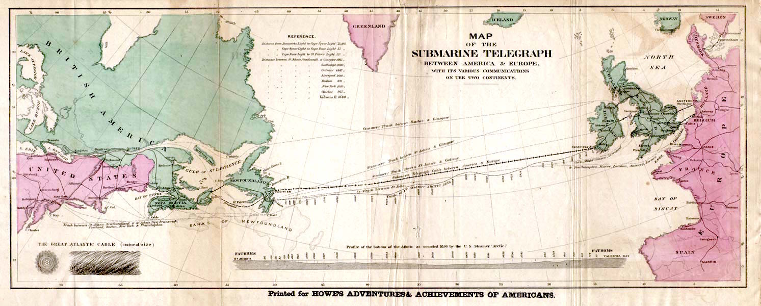
    https://upload.wikimedia.org/wikipedia/commons/f/f3/Atlantic_cable_Map.jpg


    Map of the 1858 transatlantic cable route


    https://upload.wikimedia.org/wikipedia/commons/f/f3/Atlantic_cable_Map.jpg


    Transatlantic telegraph cables were undersea cables running under the Atlantic Ocean for telegraph communications. Telegraphy is now an obsolete form of communication, and the cables have long since been decommissioned, but telephone and data are still carried on other transatlantic telecommunications cables. The first cable was laid in the 1850s from Valentia Island off the west coast of Ireland to Bay of Bulls, Trinity Bay, Newfoundland. The first communications occurred on 16 August 1858, but the line speed was poor, and efforts to improve it caused the cable to fail after three weeks. 

    https://en.wikipedia.org/wiki/Transatlantic_telegraph_cable