| Alexander Palace | |
|---|---|
Александровский дворец | |
 Panoramic view of the Alexander Palace in 2010 | |
 |
| General information | |
|---|---|
| Type | Imperial residence |
| Country | Russia |
| Coordinates | 59.721°N 30.3926°E |
| Construction started | 1792[1] |
| Design and construction | |
| Architect(s) | Giacomo Quarenghi[1] |
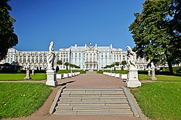
The Alexander Palace (Russian: Александровский дворец, Alexandrovskiy dvorets) is a former imperial residence near the town of Tsarskoye Selo in Russia, on a plateau about 30 miles (48 km) south of Saint Petersburg. The Palace was commissioned by Empress/Tsarina Catherine II (Catherine the Great) in 1792.
Due to the privacy it offered when officially resident in St Petersburg, the Alexander Palace was the preferred residence of the last Russian Emperor, Nicholas II and his family; its safety and seclusion compared favourably to the Winter Palace during the years immediately prior to the Russian Revolution. In 1917, the palace became the family's initial place of imprisonment after the first of two Russian Revolutions in February which overthrew the House of Romanov during World War I. The Alexander Palace is situated in Alexander Park, not far from Catherine Park and the larger, more elaborate Catherine Palace. After undergoing years of renovation, the Alexander Palace opened in Summer 2021 as a state museum housing relics of the former imperial dynasty.[2]
https://en.wikipedia.org/wiki/Alexander_Palace
| UNESCO World Heritage Site | |
|---|---|
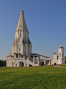 Ascension Church (1535) | |
| Location | Moscow, Russia |
| Criteria | Cultural: ii |
| Reference | 634 |
| Inscription | 1994 (18th Session) |
| Website | Official site |
| Coordinates | 55°40′10″N 37°40′08″E |
Kolomenskoye (Russian: Коло́менское) is a former royal estate situated several kilometers to the southeast of the city center of Moscow, Russia, on the ancient road leading to the town of Kolomna (hence the name). The 390 hectare scenic area overlooks the steep banks of the Moskva River. It became a part of Moscow in the 1960s.
https://en.wikipedia.org/wiki/Kolomenskoye
Saint Michael's Castle (Russian: Миха́йловский за́мок, Mikhailovsky zamok), also called the Mikhailovsky Castle or the Engineers' Castle (Russian: Инженерный замок, Inzhenerny zamok), is a former royal residence in the historic centre of Saint Petersburg, Russia. Saint Michael's Castle was built as a residence for Emperor Paul I of Russia by architects Vincenzo Brenna and Vasily Bazhenov in 1797–1801. It was named for St Michael the Archangel, patron saint of the royal family.[1] The castle looks different from each side, as the architects used motifs of various architectural styles such as French Classicism, Italian Renaissance and Gothic.
https://en.wikipedia.org/wiki/Saint_Michael%27s_Castle
Smolny Convent or Smolny Convent of the Resurrection (Voskresensky, Russian: Воскресенский новодевичий Смольный монастырь), located on Ploschad Rastrelli (Rastrelli Square), on the left bank of the River Neva in Saint Petersburg, Russia, consists of a cathedral (sobor) and a complex of buildings surrounding it, originally planned as a convent.[1]
https://en.wikipedia.org/wiki/Smolny_Convent
| Marble Palace | |
|---|---|
Мраморный дворец | |
 Larger Marble Palace. View from the Field of Mars | |
| General information | |
| Town or city | St. Petersburg |
| Country | Russia |
| Coordinates | 59°56′42.64″N 30°19′36.47″E |
| Completed | 1785 |
Marble Palace (Мраморный дворец) is one of the first Neoclassical palaces in Saint Petersburg, Russia. It is situated between the Field of Mars and Palace Quay, slightly to the east from New Michael Palace.
https://en.wikipedia.org/wiki/Marble_Palace
Kremlin Palace and churches. Early 1920s
https://en.wikipedia.org/wiki/Grand_Kremlin_Palace
Emperor's Railway Station / Emperor's Tsarskoye Selo Station | |
|---|---|
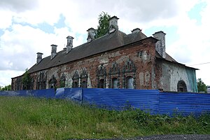 Emperor's Tsarskoye Selo Station building, in its present semi-ruined state, as seen from the North West | |
| General information | |
| Location | Akademicheskiy Prospect, Pushkin, Saint Petersburg Russia |
| Coordinates | 59°43′53″N 30°23′03″E |
| Construction | |
| Structure type | Russian Revival architecture |
| History | |
| Opened | 1895 (current building 1912) |
| Closed | 1940s |
| Rebuilt | 1911–1912 |
The Emperor's railway station or Emperor's Tsarskoye Selo Station, known as the Emperor's Pavilion (Russian: Императорский павильон, transliteration Imperatorsky pavilyon), is a former railway station terminal in Russia, in the town Tsarskoye Selo (now Pushkin, Saint Petersburg), which served the last monarch of Russia Emperor Nicholas II with his family and courtiers over his dedicated Emperor's Tsarskoye Selo Railway that eventually consisted of three lines to link the capital city of the empire, Saint Petersburg, with two of the suburban royal residences in the towns of Tsarskoye Selo (Rus. "Royal Village") and Gatchina. The Tsarskoye Selo Alexander Palace and Park estate was home to Nicholas and his family for their last 13 years. The Russian royal family had two other private railway station terminals named Emperor's Pavilions - one in Moscow and another one at Saint Petersburg Vitebsky railway station.
https://en.wikipedia.org/wiki/Imperatorsky_pavilyon_railway_station
Pella Palace (Пеллинский дворец) was a summer residence built during the reign of Catherine II of Russia for her grandson, future emperor Alexander. It was situated on the left bank of the Neva River, 30 km east of Saint Petersburg, where the town of Otradnoye now stands. If completed, it would have been Russia's largest imperial palace.[1] Pella, partially built in 1785-1789, has been razed to the ground by Catherine's son, Paul I of Russia. Not only the buildings disappeared, but very few images of it survived the Battle of the Palaces: existing knowledge of Pella relies on a few facade elevations and watercolors by Giacomo Quarenghi and an elaborate drawing on Catherine's fan, also based on Quarenghi's drafts.[2][3]
https://en.wikipedia.org/wiki/Pella_Palace
Petrovsky Palace or Petroff Palace, is a palace located in Moscow on Leningradsky Prospect. It was founded in 1780 under the orders of Catherine the Great.[1]
https://en.wikipedia.org/wiki/Petrovsky_Palace
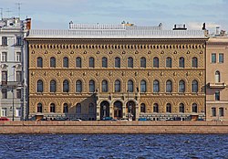
The Vladimir Palace (Russian: Влади́мирский дворе́ц, Vladimirsky dvorets) is the former palace of Grand Duke Vladimir Alexandrovich of Russia, son of Alexander II. It was one of the last imperial palaces to be constructed in Saint Petersburg, Russia. It was designed by a team of architects including Vasily Kenel, Aleksandr Rezanov, Andrei Huhn, Ieronim Kitner, Vladimir Shreter and Maximilian Messmacher. Construction work on the waterfront lasted from 1867 to 1872, additional construction and extensions continued in the 1880s and 1890s. Major restorations were made in 1980s and in 2010.
https://en.wikipedia.org/wiki/Vladimir_Palace
Tsarskoye Selo (Russian: Ца́рское Село́, IPA: [ˈtsarskəɪ sʲɪˈlo] (![]() listen), lit. 'Tsar's Village') was the town containing a former residence of the Russian imperial family and visiting nobility, located 24 kilometers (15 mi) south from the center of Saint Petersburg.[1] The residence now forms part of the town of Pushkin. Tsarskoye Selo forms one of the World Heritage Site Saint Petersburg and Related Groups of Monuments.
listen), lit. 'Tsar's Village') was the town containing a former residence of the Russian imperial family and visiting nobility, located 24 kilometers (15 mi) south from the center of Saint Petersburg.[1] The residence now forms part of the town of Pushkin. Tsarskoye Selo forms one of the World Heritage Site Saint Petersburg and Related Groups of Monuments.
The town bore the name Tsarskoye Selo until 1918. The new Bolshevik government of Soviet Russia renamed it as Detskoe Selo (Russian: Детское Село, lit. 'Children's Village'), which it held from 1918–1937. At that time, it was renamed under Stalin's government as Pushkin (Russian: Пушкин) after the famous Russian poet and writer. It is still known by that name.
https://en.wikipedia.org/wiki/Tsarskoye_Selo
The Summer Palace (Russian: Ле́тний дворе́ц) is either of the two wooden Baroque palaces built by Francesco Bartolomeo Rastrelli on Tsaritsa's Meadow behind the Summer Garden in St. Petersburg. Neither building survives.
https://en.wikipedia.org/wiki/Summer_Palace_(Rastrelli)
Leib Guard reception at the Konstantin Palace. A 19th-century painting.
https://en.wikipedia.org/wiki/Strelna
| UNESCO World Heritage Site | |
|---|---|
 | |
| Location | Saint Petersburg, Russia |
| Criteria | Cultural: (i), (ii), (iv), (vi) |
| Reference | 540bis |
| Inscription | 1990 (14th Session) |
| Extensions | 2013 |
| Area | 3,934.1 ha (15.190 sq mi) |
| Coordinates | 59°57′0″N 30°19′6″E |
The Historic Centre of Saint Petersburg and Related Groups of Monuments is the name used by UNESCO when it collectively designated the historic core of the Russian city of St. Petersburg, as well as buildings and ensembles located in the immediate vicinity as a World Heritage Site in 1991.
The site was recognised for its architectural heritage, fusing Baroque, Neoclassical, and traditional Russian-Byzantine influences.
https://en.wikipedia.org/wiki/Historic_Centre_of_Saint_Petersburg_and_Related_Groups_of_Monuments
| UNESCO World Heritage Site | |
|---|---|
 | |
| Reference | 540-003a3 |
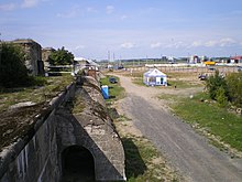
The Fort Constantin (Fort Grand Duke Constantine, Fort Konstantin) (Russian: Форт «Константин», (Форт «Великий Князь Константин») was a coastal artillery battery that covered southern waters of the fortified city of Kronstadt, Russia. The city is located on the Kotlin Island, Gulf of Finland, Baltic Sea. Currently the fort has no military use, the structures are in disarray, and the transport and tourism company Third Park tries to develop the territory as a tourist destination. [1][2][3]
https://en.wikipedia.org/wiki/Fort_Constantin_(Russia)
The Cathedral of St. Andrew (1817–1932), patron saint of the Russian Navy, destroyed by the Soviet regime in 1932.
https://en.wikipedia.org/wiki/Kronstadt
German aerial reconnaissance shot of Kronstadt, June 1, 1942
https://en.wikipedia.org/wiki/Kronstadt
Warehouse
https://en.wikipedia.org/wiki/Kronstadt
Krasnaya Gorka (Красная Горка meaning Red Hill) is a coastal artillery fortress in Lomonosovsky District, Leningrad Oblast, Russia. It is located on the southern shore of the Gulf of Finland, opposite Kotlin Island and the Baltic Fleet's base at Kronstadt. The nearest settlement is Lebyazhye (Лебяжье).
https://en.wikipedia.org/wiki/Krasnaya_Gorka_fort
Komarovo (Russian: Комаро́во, IPA: [kəmɐˈrovə]; Finnish: Kellomäki) is a municipal settlement in Kurortny District of the federal city of St. Petersburg, Russia, located on the Karelian Isthmus on the shore of the Gulf of Finland, and a station of the Saint Petersburg-Vyborg railroad. It is located about 45 kilometers (28 mi) northwest of central Saint Petersburg. Population: 1,230 (2010 Census);[1] 1,062 (2002 Census);[2] 1,635 (1989 Census).[3]
During the summer months, the population increases by a factor of five to six.[2]
https://en.wikipedia.org/wiki/Komarovo,_Saint_Petersburg
| Ligovsky canal Russian: Лиговский канал | |
|---|---|
 The Ligovsky canal near Znamenskaya Church. 1860s | |
| Specifications | |
| Maximum height above sea level | 78.9 ft (24.0 m) (Difference between a mouth and a source in meter) |
| Status | 90 % closed |
| History | |
| Principal engineer | G. Skornyakov-Pisarev |
| Construction began | 1718 |
| Date completed | 1721 |
| Date closed | 1891, 1926 and 1965-1969 |
The Ligovsky Canal (Russian: Ли́говский кана́л) is one of the longest canals of Saint Petersburg (Russia). Constructed in 1721, it is 23 kilometres (14 mi) long. Its purpose was to supply water for the fountains of the Summer Garden. The canal delivered water from the river to ponds on the current Nekrasov Street.
https://en.wikipedia.org/wiki/Ligovsky_Canal
Water system of Ligovsky Canal | ||||||||||||||||||||||||||||||||||||||||||||||||||||||||||||||||||||||||||||||||||||||||||||||||||||||||||||||||||||||||||||||||||||||||||||||||||||||||||||||||||||||||||||||||||||||||||||||||||||
|---|---|---|---|---|---|---|---|---|---|---|---|---|---|---|---|---|---|---|---|---|---|---|---|---|---|---|---|---|---|---|---|---|---|---|---|---|---|---|---|---|---|---|---|---|---|---|---|---|---|---|---|---|---|---|---|---|---|---|---|---|---|---|---|---|---|---|---|---|---|---|---|---|---|---|---|---|---|---|---|---|---|---|---|---|---|---|---|---|---|---|---|---|---|---|---|---|---|---|---|---|---|---|---|---|---|---|---|---|---|---|---|---|---|---|---|---|---|---|---|---|---|---|---|---|---|---|---|---|---|---|---|---|---|---|---|---|---|---|---|---|---|---|---|---|---|---|---|---|---|---|---|---|---|---|---|---|---|---|---|---|---|---|---|---|---|---|---|---|---|---|---|---|---|---|---|---|---|---|---|---|---|---|---|---|---|---|---|---|---|---|---|---|---|---|---|---|
| ||||||||||||||||||||||||||||||||||||||||||||||||||||||||||||||||||||||||||||||||||||||||||||||||||||||||||||||||||||||||||||||||||||||||||||||||||||||||||||||||||||||||||||||||||||||||||||||||||||
https://en.wikipedia.org/wiki/Ligovsky_Canal
 General view | |
| Monastery information | |
|---|---|
| Order | Russian Orthodox Church |
| Established | 1345 |
| People | |
| Founder(s) | Sergius of Radonezh |
| Site | |
| Location | Sergiyev Posad, Russia |
|
| |
| Official name | Architectural Ensemble of the Trinity Sergius Lavra in Sergiev Posad |
| Criteria | Cultural: (ii), (iv) |
| Reference | 657 |
| Inscription | 1993 (17th Session) |
| Area | 22.75 ha (0.0878 sq mi) |
| Buffer zone | 15.57 ha (0.0601 sq mi) |
| Website | www |
| Coordinates | 56°18′37.26″N 38°7′52.32″E |
The Trinity Lavra of St. Sergius (Russian: Тро́ице-Се́ргиева ла́вра) is the most important Russian monastery and the spiritual centre of the Russian Orthodox Church. The monastery is situated in the town of Sergiyev Posad, about 70 km to the north-east from Moscow by the road leading to Yaroslavl, and currently is home to over 300 monks.
https://en.wikipedia.org/wiki/Trinity_Lavra_of_St._Sergius
| Lake Baikal | |
|---|---|
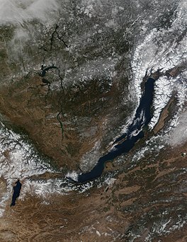 Satellite photo of Baikal, 2001 | |
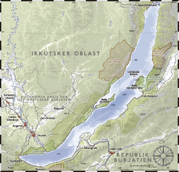 | |
| Location | Siberia, Russia |
| Coordinates | 53°30′N 108°0′E |
| Lake type | Ancient lake, Continental rift lake |
| Native name | |
| Primary inflows | Selenga, Barguzin, Upper Angara |
| Primary outflows | Angara |
| Catchment area | 560,000 km2 (216,000 sq mi) |
| Basin countries | Mongolia and Russia |
| Max. length | 636 km (395 mi) |
| Max. width | 79 km (49 mi) |
| Surface area | 31,722 km2 (12,248 sq mi)[1] |
| Average depth | 744.4 m (2,442 ft; 407.0 fathoms)[1] |
| Max. depth | 1,642 m (5,387 ft; 898 fathoms)[1] |
| Water volume | 23,610 km3 (5,660 cu mi)[1] |
| Residence time | 330 years[2] |
| Shore length1 | 2,100 km (1,300 mi) |
| Surface elevation | 455.5 m (1,494 ft) |
| Frozen | January–May |
| Islands | 27 (Olkhon Island) |
| Settlements | Severobaykalsk, Slyudyanka, Baykalsk, Ust-Barguzin |
|
| |
| Criteria | Natural: vii, viii, ix, x |
| Reference | 754 |
| Inscription | 1996 (20th Session) |
| Area | 8,800,000 ha |
| 1 Shore length is not a well-defined measure. | |
Lake Baikal (/baɪˈkɑːl, -ˈkæl/,[3] Russian: Oзеро Байкал, romanized: Ozero Baykal [ˈozʲɪrə bɐjˈkaɫ])[a] is a rift lake in Russia. It is situated in southern Siberia, between the federal subjects of Irkutsk Oblast to the northwest and the Republic of Buryatia to the southeast. With 23,615.39 km3 (5,670 cu mi) of water,[1] Lake Baikal is the world's largest freshwater lake by volume, containing 22–23% of the world's fresh surface water,[5][6] more than all of the North American Great Lakes combined.[7] It is also the world's deepest lake,[8] with a maximum depth of 1,642 metres (5,387 feet; 898 fathoms),[1] and the world's oldest lake,[9] at 25–30 million years.[10][11] At 31,722 km2 (12,248 sq mi)—slightly larger than Belgium—Lake Baikal is the world's seventh-largest lake by surface area.[12] It is among the world's clearest lakes.[13]
Lake Baikal is home to thousands of species of plants and animals, many of them endemic to the region. It is also home to Buryat tribes, who raise goats, camels, cattle, sheep, and horses[14] on the eastern side of the lake,[15] where the mean temperature varies from a winter minimum of −19 °C (−2 °F) to a summer maximum of 14 °C (57 °F).[16] The region to the east of Lake Baikal is referred to as Transbaikalia or as the Transbaikal,[17] and the loosely defined region around the lake itself is sometimes known as Baikalia. UNESCO declared Baikal a World Heritage Site in 1996.[18]
https://en.wikipedia.org/wiki/Lake_Baikal
| UNESCO World Heritage Site | |
|---|---|
 | |
| Location | Krasnodar Region, Russia |
| Criteria | Natural: (ix), (x) |
| Reference | 900 |
| Inscription | 1999 (23rd Session) |
| Area | 298,903 ha (738,610 acres) |
| Coordinates | 44°N 40°E |
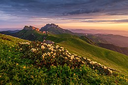
The Western Caucasus is a western region of the Caucasus in Southern Russia, extending from the Black Sea to Mount Elbrus.
https://en.wikipedia.org/wiki/Western_Caucasus
| UNESCO World Heritage Site | |
|---|---|
 Koryaksky volcano rising above Petropavlovsk-Kamchatsky | |
| Location | Kamchatka Krai, Russia |
| Includes |
|
| Criteria | Natural: (vii)(viii)(ix)(x) |
| Reference | 765bis |
| Inscription | 1996 (20th Session) |
| Extensions | 2001 |
| Area | 3,830,200 ha (14,788 sq mi) |
| Coordinates | 56°20′N 158°30′E |
The volcanoes of Kamchatka are a large group of volcanoes situated on the Kamchatka Peninsula, in eastern Russia. The Kamchatka River and the surrounding central side valley are flanked by large volcanic belts containing around 160 volcanoes, 29 of them still active. The peninsula has a high density of volcanoes and associated volcanic phenomena, with 29 active volcanoes being included in the six UNESCO World Heritage List sites in the Volcanoes of Kamchatka group, most of them on the Kamchatka Peninsula.[1]
https://en.wikipedia.org/wiki/Volcanoes_of_Kamchatka
Uvs Lake Basin | |
|---|---|
 | |
| Coordinates: 50°10′N 93°50′E | |
| Countries | Russia and Mongolia |
| States | Tuva (Russia) |
| Provinces | Uvs, Zavkhan and Khövsgöl in Mongolia |
| Districts | Mongun-Tayginsky, Ovyursky, Tes-Khemsky and Erzinsky in Tuva |
| Area | |
| • Total | 70,000 km2 (30,000 sq mi) |
| • Protected | 10,688 km2 (4,127 sq mi) |
| Ubsunorskaya Kotlovina (Russia) | |
| Area | 2,843 km2 (1,098 sq mi) |
| Designation | Biosphere Reserve |
| Designated | 1997 |
| Uvs Nuur Basin (Mongolia) | |
| Area | 7,717 km2 (2,980 sq mi) |
| Designation | Biosphere Reserve |
| Designated | 1997 |
| Location | Russia and Mongolia |
| Includes | |
| Criteria | Natural: (ix)(x) |
| Reference | 769rev |
| Inscription | 2003 (27th Session) |
| Area | 8,980.635 km2 (3,467.443 sq mi) |
| Buffer zone | 1,707.90 km2 (659.42 sq mi) |
| Official name | Lake Uvs and its surrounding wetlands |
| Designated | 2004 |
| Country | Mongolia |
| Area | 5,850 km2 (2,260 sq mi) |
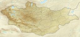
Uvs Lake Basin (also Uvs Nuur Basin or Ubs Nuur Basin; Mongolian: Увс нуурын хотгор, romanized: Uws nuuriin hotgor) is an endorheic basin located on the territorial border of Mongolia and Tuva, a republic of the Russian Federation. The basin is part of the Central Asian Internal Drainage Basin and is named after Uvs Lake (Uvs Nuur, Ubsu Nur), a large saline lake situated in the western part of its drainage basin and is one of the last remnants of the mammoth steppes. Uvs Lake is a shallow lake with an area of 3,350 km2 (1,290 sq mi). Its entire basin, which includes several smaller lakes, is 70,000 km2 (27,000 sq mi).[1]
https://en.wikipedia.org/wiki/Uvs_Lake_Basin
| Tes River Тес-Хем, Tes Xem | |
|---|---|
 | |
| Native name | Тэс гол (Mongolian) |
| Location | |
| Country | Mongolia, Russia |
| Mongolian Aimags | Khövsgöl, Zavkhan |
| Russian Region | Tuva |
| Physical characteristics | |
| Source | Shavar Türüü |
| • location | Bulnain Nuruu, Tsagaan-Uul, Mongolia |
| Mouth | Uvs Nuur |
• location | Tes, Uvs, Mongolia |
• coordinates | 50°28′35″N 93°03′58″E |
• elevation | 759 m (2,490 ft) |
| Length | 568 km (353 mi) |
| Basin size | 33,368 km2 (12,883 sq mi) |
| Basin features | |
| Tributaries | |
| • right | Shavar River, Tsereg River, Khachig River, Erzin River |
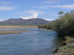
The Tes River (Mongolian: Тэс гол; Tuvan: Тес-Хем; Chinese: 特斯河, 特斯高勒) is a river in northwestern Mongolia and southern Tuva, Russia. Its spring is in Tsagaan-Uul sum in Khövsgöl. The river then flows through Zavkhan (Mongolia), Tuva (Russia), next back to Uvs (Mongolia) before entering Uvs Lake. While in Khövsgöl, there is a wooden bridge near Tsetserleg and a concrete bridge near Bayantes on the road to Kyzyl, Russia.
The Tes River is primary source of the Uvs Lake. A large section of the river, from where it enters the Uvs Province to its mound in the lake, is included in the Uvs Nuur Basin UNESCO World Heritage Site.[1]
https://en.wikipedia.org/wiki/Tes_River
| Uvs Lake | |
|---|---|
 | |
| Coordinates | 50°18′N 92°42′E |
| Type | Saline |
| Primary inflows | Tesiin gol and others |
| Primary outflows | none |
| Basin countries | Mongolia and Russia |
| Max. length | 84 km (52 mi) |
| Max. width | 79 km (49 mi) |
| Surface area | 3,350 km2 (1,290 sq mi) |
| Average depth | 6 m (20 ft) |
| Surface elevation | 759 m (2,490 ft) |
| Settlements | Ulaangom |
| Official name | Lake Uvs and its surrounding wetlands |
| Designated | 22 March 2004 |
| Reference no. | 1379[1] |
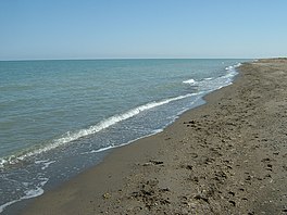
Uvs Lake (Mongolian: Увс нуур, romanized: Uws nuur, pronounced [ʊw̜s ˈnʊːr]; Russian: Озеро Убсу-Нур, romanized: Ozero Ubsu-Nur) is a highly saline lake in an endorheic basin—Uvs Nuur Basin, primarily in Mongolia with a smaller part in Russia. It is the largest lake in Mongolia by surface area, covering 3,350 km2 at 759 m above sea level.[2] The northeastern tip of the lake is situated in the Tuva Republic of the Russian Federation. The largest settlement near the lake is Ulaangom. This shallow and very saline body of water is a remainder of a huge saline sea which covered a much larger area several thousand years ago.
https://en.wikipedia.org/wiki/Uvs_Lake

Tuvan on a horse
https://en.wikipedia.org/wiki/Tuvans
According to Ilya Zakharov of Moscow's Vavilov Institute of General Genetics, genetic evidence suggests that the Tuvan people are among the close genetic relatives to the indigenous peoples of the Americas in Eurasia.[22][23]
https://en.wikipedia.org/wiki/Tuvans
Kazan Kreml' in 1630
https://en.wikipedia.org/wiki/Kazan_Kremlin
https://en.wikipedia.org/wiki/List_of_Kazan_khans
Kazan Kreml' in 1911
https://en.wikipedia.org/wiki/Kazan_Kremlin
- https://en.wikipedia.org/wiki/Kazan_Kremlin

https://en.wikipedia.org/wiki/Kazan_Kremlin
The River Seine is just out of sight to the left in this 1981 image of the then Quai du Louvre, with the Quai des Tuileries beyond.Engraving of the south façade of the Louvre, on the Quai du Louvre, from Jean Mariette's L'Architecture françoise (1738)The Quai François Mitterrand is a quay by the River Seine in Paris, France, along the stretch where the Palais du Louvre is situated. Formerly Quai du Louvre, it was renamed Quai François Mitterrand after the former French president on October 26, 2003.[citation needed]
https://en.wikipedia.org/wiki/Quai_Fran%C3%A7ois_Mitterrand
https://en.wikipedia.org/wiki/Reconstruction_(architecture)?wprov=srpw1_119
Lithography of the Moorish Castle, a theater built in Moorish Architecture. Location was Frederiksberg, Denmark
https://en.wikipedia.org/wiki/Moorish_Revival_architecture
The Quai François Mitterrand is a quay by the River Seine in Paris, France, along the stretch where the Palais du Louvre is situated. Formerly Quai du Louvre, it was renamed Quai François Mitterrand after the former French president on October 26, 2003.[citation needed]
References
This section needs expansion. You can help by adding to it. (July 2010) |
External links
https://en.wikipedia.org/wiki/Quai_Fran%C3%A7ois_Mitterrand
The Ryrie Building (1913–15) in Toronto, Canada
https://en.wikipedia.org/wiki/Palazzo_style_architecture
https://en.wikipedia.org/wiki/Vienna#Architecture






No comments:
Post a Comment