Phylogeny
Because moa are a group of flightless birds with no vestiges of wing bones, questions have been raised about how they arrived in New Zealand, and from where. Many theories exist about the moa's arrival and radiation in New Zealand, but the most recent theory suggests that they arrived in New Zealand about 60 million years ago (Mya) and split from the "basal" (see below) moa species, Megalapteryx, about 5.8 Mya[27] instead of the 18.5 Mya split suggested by Baker et al. (2005). This does not necessarily mean there was no speciation between the arrival 60 Mya and the basal split 5.8 Mya, but the fossil record is lacking and most likely the early moa lineages existed, but became extinct before the basal split 5.8 Mya.[28] The presence of Miocene-aged species certainly suggests that moa diversification began before the split between Megalapteryx and the other taxa.[26]
The Oligocene Drowning Maximum event, which occurred about 22 Mya, when only 18% of present-day New Zealand was above sea level, is very important in the moa radiation. Because the basal moa split occurred so recently (5.8 Mya), it was argued that ancestors of the Quaternary moa lineages could not have been present on both the South and North Island remnants during the Oligocene drowning.[29] This does not imply that moa were previously absent from the North Island, but that only those from the South Island survived, because only the South Island was above sea level. Bunce et al. (2009) argued that moa ancestors survived on the South Island and then recolonised the North Island about 2 My later, when the two islands rejoined after 30 My of separation.[19] The presence of Miocene moa in the Saint Bathans fauna seems to suggest that these birds increased in size soon after the Oligocene Drowning Event, if they were affected by it at all.[26]
Bunce et al. also concluded that the highly complex structure of the moa lineage was caused by the formation of the Southern Alps about 6 Mya, and the habitat fragmentation on both islands resulting from Pleistocene glacial cycles, volcanism, and landscape changes.[19] The cladogram below is a phylogeny of Palaeognathae generated by Mitchell (2014)[15] with some clade names after Yuri et al. (2013).[30] It provides the position of the moa (Dinornithiformes) within the larger context of the "ancient jawed" (Palaeognathae) birds:
| Palaeognathae |
| ||||||||||||||||||||||||||||||||||||||||||
|
|
The cladogram below gives a more detailed, species-level phylogeny, of the moa branch (Dinornithiformes) of the "ancient jawed" birds (Palaeognathae) shown above:[19]
| †Dinornithiformes |
| ||||||||||||||||||||||||||||||||||||||||||||||||||||||
|
|
https://en.wikipedia.org/wiki/Moa
Significantly less is known about North Island paleofaunas, due to a paucity of fossil sites compared to the South Island, but the basic pattern of moa-habitat relationships was the same.[11] The South Island and the North Island shared some moa species (Euryapteryx gravis, Anomalopteryx didiformis), but most were exclusive to one island, reflecting divergence over several thousand years since lower sea level in the Ice Age had made a land bridge across the Cook Strait.[11]

https://en.wikipedia.org/wiki/Moa

Preserved footprints of a D. novaezealandiae found in 1911
https://en.wikipedia.org/wiki/Moa
Isotope analysis is the identification of isotopic signature, abundance of certain stable isotopes of chemical elements within organic and inorganic compounds. Isotopic analysis can be used to understand the flow of energy through a food web, to reconstruct past environmental and climatic conditions, to investigate human and animal diets, for food authentification, and a variety of other physical, geological, palaeontological and chemical processes. Stable isotope ratios are measured using mass spectrometry, which separates the different isotopes of an element on the basis of their mass-to-charge ratio.
https://en.wikipedia.org/wiki/Isotope_analysis
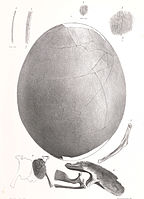
Fragments of moa eggshell are often found in archaeological sites and sand dunes around the New Zealand coast. Thirty-six whole moa eggs exist in museum collections and vary greatly in size (from 120–240 millimetres (4.7–9.4 in) in length and 91–178 millimetres (3.6–7.0 in) wide).[47] The outer surface of moa eggshell is characterised by small, slit-shaped pores. The eggs of most moa species were white, although those of the upland moa (Megalapteryx didinus) were blue-green.[48]
https://en.wikipedia.org/wiki/Moa
Fragments of moa eggshell are often found in archaeological sites and sand dunes around the New Zealand coast. Thirty-six whole moa eggs exist in museum collections and vary greatly in size (from 120–240 millimetres (4.7–9.4 in) in length and 91–178 millimetres (3.6–7.0 in) wide).[47] The outer surface of moa eggshell is characterised by small, slit-shaped pores. The eggs of most moa species were white, although those of the upland moa (Megalapteryx didinus) were blue-green.[48]
A 2010 study by Huynen et al. found that the eggs of certain species were fragile, only around a millimetre in shell thickness: "Unexpectedly, several thin-shelled eggs were also shown to belong to the heaviest moa of the genera Dinornis, Euryapteryx, and Emeus, making these, to our knowledge, the most fragile of all avian eggs measured to date. Moreover, sex-specific DNA recovered from the outer surfaces of eggshells belonging to species of Dinornis and Euryapteryx suggest that these very thin eggs were likely to have been incubated by the lighter males. The thin nature of the eggshells of these larger species of moa, even if incubated by the male, suggests that egg breakage in these species would have been common if the typical contact method of avian egg incubation was used."[48] Despite the bird's extinction, the high yield of DNA available from recovered fossilised eggs has allowed the moa's genome to be sequenced.[49]
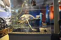
The skeleton of female upland moa with egg in unlaid position within the pelvic cavity in Otago Museum
An egg and embryo fragments of Emeus crassus
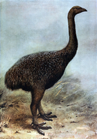
Restoration of an upland moa


https://en.wikipedia.org/wiki/Moa
Studies of accumulated dried vegetation in the pre-human mid-late Holocene period suggests a low Sophora microphylla or Kōwai forest ecosystem in Central Otago that was used and perhaps maintained by moa, for both nesting material and food. Neither the forests nor moa existed when European settlers came to the area in the 1850s.[50]
https://en.wikipedia.org/wiki/Moa
Radiocarbon dating (also referred to as carbon dating or carbon-14 dating) is a method for determining the age of an object containing organic material by using the properties of radiocarbon, a radioactive isotope of carbon.
The method was developed in the late 1940s at the University of Chicago by Willard Libby. It is based on the fact that radiocarbon (14
C) is constantly being created in the Earth's atmosphere by the interaction of cosmic rays with atmospheric nitrogen. The resulting 14
C combines with atmospheric oxygen to form radioactive carbon dioxide, which is incorporated into plants by photosynthesis; animals then acquire 14
C
by eating the plants. When the animal or plant dies, it stops
exchanging carbon with its environment, and thereafter the amount of 14
C it contains begins to decrease as the 14
C undergoes radioactive decay. Measuring the amount of 14
C
in a sample from a dead plant or animal, such as a piece of wood or a
fragment of bone, provides information that can be used to calculate
when the animal or plant died. The older a sample is, the less 14
C there is to be detected, and because the half-life of 14
C
(the period of time after which half of a given sample will have
decayed) is about 5,730 years, the oldest dates that can be reliably
measured by this process date to approximately 50,000 years ago,
although special preparation methods occasionally make an accurate
analysis of older samples possible. Libby received the Nobel Prize in Chemistry for his work in 1960.
Research has been ongoing since the 1960s to determine what the proportion of 14
C
in the atmosphere has been over the past fifty thousand years. The
resulting data, in the form of a calibration curve, is now used to
convert a given measurement of radiocarbon in a sample into an estimate
of the sample's calendar age. Other corrections must be made to account
for the proportion of 14
C in different types of organisms (fractionation), and the varying levels of 14
C throughout the biosphere
(reservoir effects). Additional complications come from the burning of
fossil fuels such as coal and oil, and from the above-ground nuclear
tests done in the 1950s and 1960s. Because the time it takes to convert
biological materials to fossil fuels is substantially longer than the time it takes for its 14
C to decay below detectable levels, fossil fuels contain almost no 14
C. As a result, beginning in the late 19th century, there was a noticeable drop in the proportion of 14
C as the carbon dioxide generated from burning fossil fuels began to accumulate in the atmosphere. Conversely, nuclear testing increased the amount of 14
C
in the atmosphere, which reached a maximum in about 1965 of almost
double the amount present in the atmosphere prior to nuclear testing.
Measurement of radiocarbon was originally done by beta-counting devices, which counted the amount of beta radiation emitted by decaying 14
C atoms in a sample. More recently, accelerator mass spectrometry has become the method of choice; it counts all the 14
C
atoms in the sample and not just the few that happen to decay during
the measurements; it can therefore be used with much smaller samples (as
small as individual plant seeds), and gives results much more quickly.
The development of radiocarbon dating has had a profound impact on archaeology.
In addition to permitting more accurate dating within archaeological
sites than previous methods, it allows comparison of dates of events
across great distances. Histories of archaeology often refer to its
impact as the "radiocarbon revolution". Radiocarbon dating has allowed
key transitions in prehistory to be dated, such as the end of the last ice age, and the beginning of the Neolithic and Bronze Age in different regions.
https://en.wikipedia.org/wiki/Radiocarbon_dating

Sir Richard Owen holding the first discovered moa fossil and standing with a Dinornis skeleton, 1879
https://en.wikipedia.org/wiki/Moa
They occur in a range of late Quaternary and Holocene sedimentary deposits, but are most common in three main types of site: caves, dunes, and swamps.

Bones are commonly found in caves or tomo (the Māori word for doline or sinkhole, often used to refer to pitfalls or vertical cave shafts). The two main ways that the moa bones were deposited in such sites were birds that entered the cave to nest or escape bad weather, and subsequently died in the cave and birds that fell into a vertical shaft and were unable to escape. Moa bones (and the bones of other extinct birds) have been found in caves throughout New Zealand, especially in the limestone/marble areas of northwest Nelson, Karamea, Waitomo, and Te Anau.
Moa bones and eggshell fragments sometimes occur in active coastal sand dunes, where they may erode from paleosols and concentrate in 'blowouts' between dune ridges. Many such moa bones antedate human settlement, although some originate from Māori midden sites, which frequently occur in dunes near harbours and river mouths (for example the large moa hunter sites at Shag River, Otago, and Wairau Bar, Marlborough).
Densely intermingled moa bones have been encountered in swamps throughout New Zealand. The most well-known example is at Pyramid Valley in north Canterbury,[64] where bones from at least 183 individual moa have been excavated, mostly by Roger Duff of Canterbury Museum.[65] Many explanations have been proposed to account for how these deposits formed, ranging from poisonous spring waters to floods and wildfires. However, the currently accepted explanation is that the bones accumulated slowly over thousands of years, from birds that entered the swamps to feed and became trapped in the soft sediment.[66]
Many New Zealand and international museums hold moa bone collections. Auckland War Memorial Museum – Tāmaki Paenga Hira has a significant collection, and in 2018 several moa skeletons were imaged and 3D scanned to make the collections more accessible.[67] There is also a major collection in Otago Museum in Dunedin.
Feathers and soft tissues

Several remarkable examples of moa remains have been found which exhibit soft tissues (muscle, skin, feathers), that were preserved through desiccation when the bird died in a naturally dry site (for example, a cave with a constant dry breeze blowing through it). Most of these specimens have been found in the semiarid Central Otago region, the driest part of New Zealand. These include:
- Dried muscle on bones of a female Dinornis robustus found at Tiger Hill in the Manuherikia River Valley by gold miners in 1864[68] (currently held by Yorkshire Museum)
- Several bones of Emeus crassus with muscle attached, and a row of neck vertebrae with muscle, skin, and feathers collected from Earnscleugh Cave near the town of Alexandra in 1870[69] (currently held by Otago Museum)
- An articulated foot of a male D. giganteus with skin and foot pads preserved, found in a crevice on the Knobby Range in 1874[70] (currently held by Otago Museum)
- The type specimen of Megalapteryx didinus found near Queenstown in 1878[68] (currently held by Natural History Museum, London; see photograph of foot on this page)
- The lower leg of Pachyornis elephantopus, with skin and muscle, from the Hector Range in 1884;[54][70] (currently held by the Zoology Department, Cambridge University)
- The complete feathered leg of a M. didinus from Old Man Range in 1894[71] (currently held by Otago Museum)
- The head of a M. didinus found near Cromwell sometime before 1949[72] (currently held by the Museum of New Zealand).
Two specimens are known from outside the Central Otago region:
- A complete foot of M. didinus found in a cave on Mount Owen near Nelson in the 1980s[73] (currently held by the Museum of New Zealand)
- A skeleton of Anomalopteryx didiformis with muscle, skin, and feather bases collected from a cave near Te Anau in 1980.[74]

In addition to these specimens, loose moa feathers have been collected from caves and rock shelters in the southern South Island, and based on these remains, some idea of the moa plumage has been achieved. The preserved leg of M. didinus from the Old Man Range reveals that this species was feathered right down to the foot. This is likely to have been an adaptation to living in high-altitude, snowy environments, and is also seen in the Darwin’s rhea, which lives in a similar seasonally snowy habitat.[11]
Moa feathers are up to 23 cm (9 in) long, and a range of colours has been reported, including reddish-brown, white, yellowish, and purplish.[11] Dark feathers with white or creamy tips have also been found, and indicate that some moa species may have had plumage with a speckled appearance.[75]
Claims of survival

Occasional speculation – since at least the late 19th century,[76][77] and as recently as 1993[78][79][80] and 2008[81] – has occurred that some moa may still exist, particularly in the wilderness of South Westland and Fiordland. The 1993 report initially interested the Department of Conservation, but the animal in a blurry photograph was identified as a red deer.[82][83] Cryptozoologists continue to search for them, but their claims and supporting evidence (such as of purported footprints)[81] have earned little attention from experts and are pseudoscientific.[54] In 1880 Alice Mackenzie had a meeting with a large bird that she believed to be a takahē but when it was rediscovered in the 1940s, and Mackenzie saw what it looked like, she knew she had seen something else.[84]
The rediscovery of the takahē in 1948 after none had been seen since 1898 showed that rare birds can exist undiscovered for a long time. However, the takahē is a much smaller bird than the moa, and was rediscovered after its tracks were identified—yet no reliable evidence of moa tracks has ever been found, and experts still contend that moa survival is extremely unlikely, since they would have to be living unnoticed for over 500 years in a region visited often by hunters and hikers.[81]
Potential revival
The creature has frequently been mentioned as a potential candidate for revival by cloning. Its iconic status, coupled with the facts that it only became extinct a few hundred years ago and that substantial quantities of moa remains exist, mean that it is often listed alongside such creatures as the dodo as leading candidates for de-extinction.[85] Preliminary work involving the extraction of DNA has been undertaken by Japanese geneticist Ankoh Yasuyuki Shirota.[86][87]
Interest in the moa's potential for revival was further stirred in mid-2014 when New Zealand Member of Parliament Trevor Mallard suggested that bringing back some smaller species of moa within 50 years was a viable idea.[88] The idea was ridiculed by many, but gained support from some natural history experts.[89]
https://en.wikipedia.org/wiki/Moa

Island gigantism, or insular gigantism, is a biological phenomenon in which the size of an animal species isolated on an island increases dramatically in comparison to its mainland relatives. Island gigantism is one aspect of the more general "island effect" or "Foster's rule", which posits that when mainland animals colonize islands, small species tend to evolve larger bodies, and large species tend to evolve smaller bodies (insular dwarfism). This is itself one aspect of the more general phenomenon of island syndrome which describes the differences in morphology, ecology, physiology and behaviour of insular species compared to their continental counterparts. Following the arrival of humans and associated introduced predators (dogs, cats, rats, pigs), many giant as well as other island endemics have become extinct. A similar size increase, as well as increased woodiness, has been observed in some insular plants.
https://en.wikipedia.org/wiki/Island_gigantism
.jpg)
A sinkhole is a depression or hole in the ground caused by some form of collapse of the surface layer. The term is sometimes used to refer to doline, enclosed depressions that are locally[where?] also known as vrtače and shakeholes, and to openings where surface water enters into underground passages known as ponor, swallow hole or swallet.[1][2][3][4] A cenote is a type of sinkhole that exposes groundwater underneath.[4] Sink and stream sink are more general terms for sites that drain surface water, possibly by infiltration into sediment or crumbled rock.[2]
Most sinkholes are caused by karst processes – the chemical dissolution of carbonate rocks, collapse or suffosion processes.[1][5] Sinkholes are usually circular and vary in size from tens to hundreds of meters both in diameter and depth, and vary in form from soil-lined bowls to bedrock-edged chasms. Sinkholes may form gradually or suddenly, and are found worldwide.[2][1]
https://en.wikipedia.org/wiki/Sinkhole

More than three acres of forest suddenly disappeared into this "December Giant" sinkhole in Montevallo, Alabama, USA.
https://en.wikipedia.org/wiki/Sinkhole

Gouffre de Padirac in France known since the 3rd c. and explored in 1889
https://en.wikipedia.org/wiki/Sinkhole

The Great Blue Hole near Ambergris Caye, Belize
https://en.wikipedia.org/wiki/Sinkhole
https://en.wikipedia.org/wiki/Sinkhole
Nitra | |
|---|---|
City | |
 View from the south side of Nitra Castle | |
 Flag  Coat of arms | |
 Nitra Location in Nitra Region | |
| Coordinates: 48°18′25″N 18°05′11″ECoordinates: 48°18′25″N 18°05′11″E | |
| Country | |
| Region | Nitra |
| First mentioned | 828 |
| Government | |
| • Mayor | Marek Hattas |
| Area | |
| • Total | 100.47[2] km2 (38.79[2] sq mi) |
| Elevation | 167[3] m (548[3] ft) |
| Population (2021) | |
| • Total | 77,610[1] |
| Time zone | UTC+1 (CET) |
| • Summer (DST) | UTC+2 (CEST) |
| Postal code | 949 01[3] |
| Area code | +421 37[3] |
| Car plate | NR |
| Website | www.nitra.sk |

Nitra (Slovak pronunciation: [ˈɲitra] (![]() listen); also known by other alternative names) is a city in western Slovakia, situated at the foot of Zobor Mountain in the valley of the river Nitra.
It is located 95 km east of Bratislava. With a population of about
78,353, it is the fifth largest city in Slovakia. Nitra is also one of
the oldest cities in Slovakia; it was the political center of the Principality of Nitra. Today, it is a seat of a kraj (Nitra Region), and an okres (Nitra District).
listen); also known by other alternative names) is a city in western Slovakia, situated at the foot of Zobor Mountain in the valley of the river Nitra.
It is located 95 km east of Bratislava. With a population of about
78,353, it is the fifth largest city in Slovakia. Nitra is also one of
the oldest cities in Slovakia; it was the political center of the Principality of Nitra. Today, it is a seat of a kraj (Nitra Region), and an okres (Nitra District).
https://en.wikipedia.org/wiki/Nitra
Ypres
Ieper (Dutch) | |
|---|---|
City and municipality | |
 | |
 Flag  Coat of arms | |
Location of Ypres | |
 Ypres Location in Belgium
|
Location of Ypres in West Flanders | |
| Coordinates: 50°51′03″N 02°53′06″ECoordinates: 50°51′03″N 02°53′06″E | |
| Country | |
|---|---|
| Community | Flemish Community |
| Region | Flemish Region |
| Province | West Flanders |
| Arrondissement | Ypres |
| Government | |
| • Mayor | Emmily Talpe (Open Ieper) |
| • Governing party/ies | Open Ieper, N-VA, Vooruit |
| Area | |
| • Total | 131.45 km2 (50.75 sq mi) |
| Population (2022-01-01)[1] | |
| • Total | 35,039 |
| • Density | 270/km2 (690/sq mi) |
| Postal codes | 8900, 8902, 8904, 8906, 8908 |
| Area codes | 057 |
| Website | www |
Ypres (/ˈiːprə/ EE-prə, French: [ipʁ]; Dutch: Ieper [ˈipər] (![]() listen); West Flemish: Yper; German: Ypern [ˈyːpɐn] (
listen); West Flemish: Yper; German: Ypern [ˈyːpɐn] (![]() listen)) is a Belgian city and municipality in the province of West Flanders. Though
the Dutch name Ieper is the official one, the city's French name Ypres is most commonly used in English. The municipality comprises the city of Ypres/Ieper and the villages of Boezinge, Brielen, Dikkebus, Elverdinge, Hollebeke, Sint-Jan, Vlamertinge, Voormezele, Zillebeke, and Zuidschote. Together, they are home to about 34,900 inhabitants.
listen)) is a Belgian city and municipality in the province of West Flanders. Though
the Dutch name Ieper is the official one, the city's French name Ypres is most commonly used in English. The municipality comprises the city of Ypres/Ieper and the villages of Boezinge, Brielen, Dikkebus, Elverdinge, Hollebeke, Sint-Jan, Vlamertinge, Voormezele, Zillebeke, and Zuidschote. Together, they are home to about 34,900 inhabitants.
During the First World War, Ypres (or "Wipers" as it was commonly known by the British troops) was the centre of the Battles of Ypres between German and Allied forces.
https://en.wikipedia.org/wiki/Ypres
Zacatón is a cenote (a thermal water-filled sinkhole) belonging to the Zacatón system - a group of unusual karst features located in Aldama Municipality near the Sierra de Tamaulipas in the northeastern state of Tamaulipas, Mexico. It is the deepest known water-filled sinkhole in the world with a total depth of 339 meters (1,112 ft).[1] The 392 meters (1,286 ft) deep Pozzo del Merro is deeper (actual depth unknown), but its nature as a near-vertical cave or a sinkhole still being debated.[citation needed]
Using an autonomous robot, the underwater portion of Zacatón has been measured to be 319 meters (1,047 ft) deep (a 20-meter (66 ft) difference between the rim of cliff and surface of water adds to the total depth).[2] Zacatón is the only sinkhole of the five located in Rancho La Azufrosa to have any noticeable water flow.[3]
The name Zacatón comes from the free-floating islands of zacate grass which move around on the surface with the wind.[4]
Scrapings from the rock walls beneath the surface yielded at least three new phyla of bacteria.[5]
https://en.wikipedia.org/wiki/Zacat%C3%B3n
| Devil's Millhopper Geological State Park | |
|---|---|
 Boardwalk leading down to the sinkhole's observation deck | |
 | |
| Location | Alachua County, Florida, USA |
| Nearest city | Gainesville, Florida |
| Coordinates | 29°42′25″N 82°23′42″WCoordinates: 29°42′25″N 82°23′42″W |
| Area | 67 acres (27 ha) |
| Established | 1974 |
| Governing body | Florida Department of Environmental Protection |
| Designated | December 1974 |
Devil's Millhopper Geological State Park is a Florida state park located in the north-westernmost part of Gainesville, Florida, off County Road 232, also known as NW 53rd Avenue and Millhopper Road, northwest of the University of Florida.
The park is maintained by the Florida Park Service, a division of the Florida Department of Environmental Protection. The park is adjacent to San Felasco County Park and is near the San Felasco Hammock Preserve State Park.
https://en.wikipedia.org/wiki/Devil%27s_Millhopper_Geological_State_Park

A caldera (/kɔːlˈdɛrə, kæl-/[1] kawl-DERR-ə, kal-) is a large cauldron-like hollow that forms shortly after the emptying of a magma chamber in a volcano eruption. When large volumes of magma are erupted over a short time, structural support for the rock above the magma chamber is gone. The ground surface then collapses into the emptied or partially emptied magma chamber, leaving a large depression at the surface (from one to dozens of kilometers in diameter).[2] Although sometimes described as a crater, the feature is actually a type of sinkhole, as it is formed through subsidence and collapse rather than an explosion or impact. Compared to the thousands of volcanic eruptions that occur each century, the formation of a caldera is a rare event, occurring only a few times per century.[3] Only seven caldera-forming collapses are known to have occurred between 1911 and 2016.[3] More recently, a caldera collapse occurred at Kīlauea, Hawaii in 2018.[4]
https://en.wikipedia.org/wiki/Caldera


A gully is a landform created by running water, mass movement, or commonly a combination of both eroding sharply into soil or other relatively erodible material, typically on a hillside or in river floodplains or terraces. Gullies resemble large ditches or small valleys, but are metres to tens of metres in depth and width and are characterised by a distinct 'headscarp' or 'headwall' and progress by headward (i.e. upstream) erosion. Gullies are commonly related to intermittent or ephemeral water flow usually associated with localised intense or protracted rainfall events, or snowmelt. Gullies can be formed and accelerated by cultivation practices on hillslopes (often gentle gradient) in farmland, and they can develop rapidly in rangelands from existing natural erosion forms subject to vegetative cover removal and livestock activity.
https://en.wikipedia.org/wiki/Gully
A lake-burst (Old Irish: tomaidm,[1] Irish: tomhaidhm[2]) is a phenomenon referred to in Irish mythology, in which a previously non-existent lake comes into being, often when a grave is being dug. Part of the lake-burst stories may originate in sudden hydrographic changes around limestone-based inland plains or turloughs. Other so-called lake-bursts refer to marine estuaries, bays and inlets, such as Galway Bay, Strangford Lough, Dundrum Bay, Belfast Lough, Waterford Harbour and the mouth of the River Erne. Some of these coastal districts were renowned for the drowned prehistoric forests, which gave rise to several flood-myths.
Medieval bards had a special genre of lake-burst poems called tomamond. More or less elaborate 11th- or 12th-century narratives have survived around Galway Bay, Lough Neagh and Lough Ree, which seem to be related to similar (though less ancient) stories in Wales (Cantre'r Gwaelod, Llys Helig, Bala Lake, Llynclys), Cornwall (Lyonesse), Brittany (Ys) and Normandy (Forêt de Scissy). A late 16th-century Frisian legend, probably borrowed from Irish examples, refers to the origins of the Zuiderzee. Other Irish texts refer to the eruption of the River Boyne and other rivers. The poems of the lake-burst of Lough Erne and the eruption of Brí (where the legendary character Midir lived) have been lost. In Wales the flood myth is elaborated in the story of Dwyfan and Dwyfach, who saved people and animals from the great deluge caused by the monster Avanc living in Llyn Llion (possibly Bala Lake). Its Irish counterpart as told in the Lebor Gabála Érenn only links up with the Biblical story of Noah's flood.
The theme relates to the classical story of the warrior Marcus Curtius, who was said to have thrown himself in the Lacus Curtius near the Forum Romanum in order to stop a chasm made by the river Tiber. A similar story was told about King Midas.[3]
https://en.wikipedia.org/wiki/Lake-burst


Pingos are intrapermafrost ice-cored hills, 3–70 m (10–230 ft) high and 30–1,000 m (98–3,281 ft) in diameter.[1] They are typically conical in shape and grow and persist only in permafrost environments, such as the Arctic and subarctic.[2] A pingo is a periglacial landform, which is defined as a non-glacial landform or process linked to colder climates.[3] It is estimated that there are more than 11,000 pingos on Earth.[4] The Tuktoyaktuk peninsula area has the greatest concentration of pingos in the world with a total of 1,350 pingos.[5] There is currently remarkably limited data on pingos.[5]
https://en.wikipedia.org/wiki/Pingo
A turlough (turloch or turlach in Irish[1]), is a seasonal or periodic water body found mostly in limestone karst areas of Ireland, west of the River Shannon. The name comes from the Irish tur, meaning "dry", and loch, meaning "lake". The water bodies fill and empty with the changes in the level of the water table, usually being very low or empty during summer and autumn and full in the winter. As groundwater levels drop the water drains away underground through cracks in the karstic limestone.[2]
Turloughs are almost unique to Ireland, although there is one example in Wales, Pant-y-Llyn at Cernydd Carmel near Llandeilo.[3][4] They are of great interest to many scientists: geomorphologists are interested in how turloughs were formed, hydrologists try to explain what makes turloughs flood, botanists study the unusual vegetation which covers the turlough floor, and zoologists study the animals associated with the turloughs.
https://en.wikipedia.org/wiki/Turlough_(lake)
| Dersios sinkhole | |
|---|---|
| Location | near Palaiochora in Arcadia, Greece |
| Depth | 170 metres (560 ft) |
The Dersios sinkhole (Greek: Σπηλαιοκαταβόθρα "Ο Δέρσιος" Spilaiokatavothra "O Dhersios") is a sinkhole in Arcadia, Greece.
The sinkhole, which has a depth of 170 metres (560 ft), has been known since antiquity and is located towards the north end of the plateau of Palaiochora at a height of 750 m above sea level on mount Parnon. It is about 45 minutes on unsurfaced road from the nearest town of Tyros in the Kynouria region of Arcadia. The sinkhole was first explored in August 1974 to a depth of 81 metres (266 ft) by a French team (in collaboration with the Hellenic Speleological Society). Since 2003, SELAS caving club in Greece has been exploring the cave, doubling the depth and more than tripling the length of the sinkhole. The new discoveries were made in 2003 by cave diving the first sump and emptying it by siphoning the water and in 2005 by emptying sumps in side passages of the sinkhole.
https://en.wikipedia.org/wiki/Dersios_sinkhole
In karst geology, estavelle or inversac is a ground orifice which, depending on weather conditions and season, can serve either as a sink or as a source of fresh water. It is a type of ponor or sinkhole.[1][2]
https://en.wikipedia.org/wiki/Estavelle

Akhayat (also known as Aşağı Dünya Obruğu) is a sinkhole in Mersin Province, Turkey.
The Akhayat Sinkhole is located in a rural area of the Silifke ilçe (district), to the north of Atayurt town.
https://en.wikipedia.org/wiki/Akhayat_sinkhole


A blue hole is a large marine cavern or sinkhole, which is open to the surface and has developed in a bank or island composed of a carbonate bedrock (limestone or coral reef). Their existence was discovered in the late 20th century by fishermen and recreational divers.[1] Blue holes typically contain tidally influenced water of fresh, marine, or mixed chemistry. They extend below sea level for most of their depth and may provide access to submerged cave passages.[2] Well-known examples are the Dragon Hole (in the South China Sea) and, in the Caribbean, the Great Blue Hole and Dean's Blue Hole.
Blue holes are distinguished from cenotes in that the latter are inland voids usually containing fresh groundwater rather than seawater.
https://en.wikipedia.org/wiki/Blue_hole
No comments:
Post a Comment